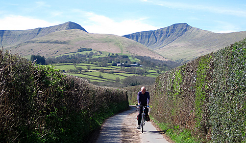
Cycling in the Brecon Beacons National Park
The Brecon Beacons [Bannau Brycheiniog in Welsh] National Park could have been made for cycling - both on-road cycling and mountain biking.
The 519 square miles of the national park stretches from Hay-on-Wye on the England/Wales border in the east to Llandeilo in the west. The park consists of 3 mountain blocks - the Black Mountains in the east, the Brecon Beacons in the centre, and Black Mountain in the west. Note that the Black Mountains and Black Mountain are not the same place! Enjoy your cycling...
An Old Name For A New Way To Be
On 17 April 2023 (the 66th anniversary of the Park's designation), the Brecon Beacons Nation Park 'officially' changed its name to Bannau Brycheiniog National Park. The change of name reflects a new commitment to addressing the climate and biodiversity emergency. A series of projects are underway to halt and reverse the impact of climate change.
Pronounced 'Ban-eye Bruck-ein-iog' the new name is derived from the plural of 'ban', meaning 'peak', while 'Brycheiniog' refers to the old kingdom of King Brychan who once ruled this area. Translated, it means ' The Peaks of Brychan's Kingdom'.
It will take a while for the new name to catch on, so in the meantime most people will probably still refer to it as The Brecon Beacons.
Monmouthshire & Brecon Canal
The best time of the year to cycle along the Monmouthshire & Brecon Canal is the autumn when the leaves are falling on the surface of the water (as in the last 2 photos below). The spring of course being the second best time.
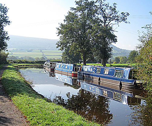
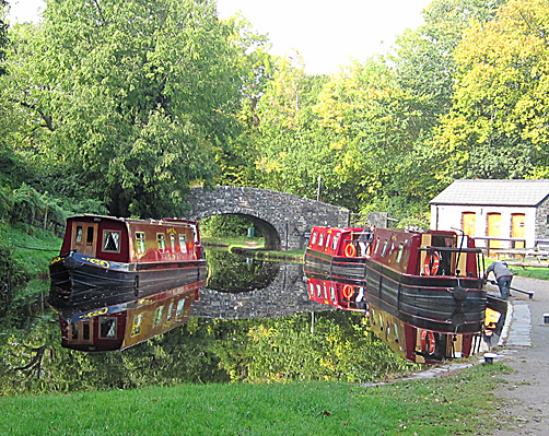

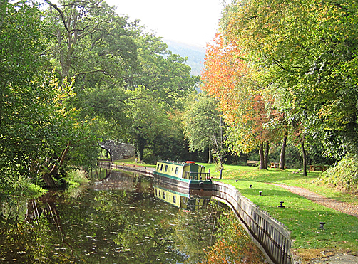
For cycling, our favourite part of the canal is between Brecon and bridge #110 just south of Llangattock, the path for the most part being easy going and extremely beautiful. More info and map.
A simple ride starting at Brecon: alternating between the canal and adjacent B4558 go as far as Crickhowell, then return using the sections of canal you didn't do on the way going. The section between the canal tunnel (south of Talybont-on-Usk) and Llangynidr is best done on the B4558 going and on the canal returning. Food stops: The Queens Head, Pencelli (pub garden next to the canal); cafe at shop by lift bridge in Talybont-on-Usk; Deb's Kitchen in The Courtyard, off Standard Street, Crickhowell (note Tools For Self Reliance Cymru also next to the courtyard).
The King of Hay-on-Wye
Once-upon-a-time in the picture-postcard border town of Hay-on-Wye something happened that hit the world's headlines. On 1st April 1977 the second-hand bookseller Richard Booth unilaterally declared independence (UDI) for the town and proclaimed himself king.
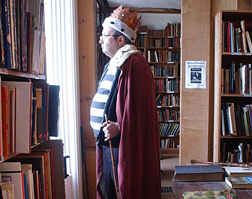
Booth had arrived from Oxford in 1961 and opened a bookshop in the town. He was a clever publicist and one night in the pub with his mates he came up with the idea of declaring UDI. As the evening progressed ministerial jobs were handed out - trouble was the next morning half of His Majesty's ministers couldn't remember which ministry they'd been given. The Minister of Sport immediately arranged a darts match with a nearby village pub.
And so it came to pass that on 1st April (All Fools Day) the King read the declaration from the battlements of his castle (Booth owned Hay castle in days of old) and the local school children sang the specially-penned Hay-on-Wye national anthem. Passports were issued, money printed (99p notes on rice paper, so at least you could eat them if the currency lost its value) and peerages sold (Earldoms cost just £5 including a free t-shirt). Local resident April Ashley (Britain's first transgender) at her own request, was given the title of Duchess of Hay & Offa's Dyke. This really was the heyday of Hay-on-Wye.

Later that year good King Richard held a party in his castle. After all the quests had retired to their beds, a log fell out of the grate and the ensuing fire destroyed much of the castle [exciting new plans are now afoot for the refurbishment].
King Richard's flair for publicity certainly put the town on the map as the world's first 'second-hand book town', but the winters can be long on the borders with few tourists turning up to keep the bookshops going.
Then one day a self-made millionaire, Leon Morrelli, rode into town and started buying up the good king's bookshops as they went bust. The rivalry between the two men came to a head in 1984 when Morrelli organised a referendum (held in one of his bookshops) to settle the issue of who should reign over Hay. A glass of wine was offered to persuade the townsfolk to turn out to vote. Surprise, surprise, 25% of the electorate voted [David Cameron could have learnt a thing or two on how to hold a referendum here]. Morrelli narrowly won by 24 votes; the King refused to abdicate.
If you want to know more about Hay's Independence, watch this BBC NationWide video report from March 1977 or this video report made on the actual day.
For more info about the town see the Hay-on-Wye website. Each year the town hosts its literature festival over two weeks at the end of May.
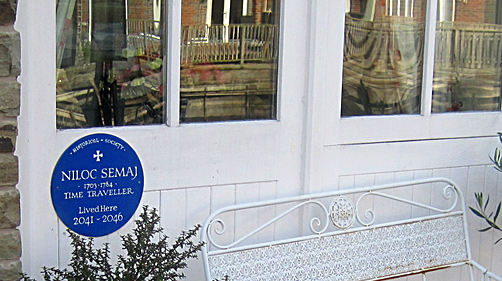
Time Traveller To Visit Brecon
If cycling into Brecon along the Brecon & Monmouth Canal, look out for a blue plaque (photo below) on #11, the penultimate new house on the left just before leaving the canal towpath. Time taveller Niloc Semaj (1703-1784) will live here 2041-2046, so remember to come cycling here again if you want to meet him - Niloc Semaj is better known locally as Colin James.
Brecon is the main town in the Brecon Beacons National Park - bike shop (in Ship St), 4 outdoor shops (Cotswolds & Gibs Sport are the best), lots of cafes (The Hours Cafe at Brecon Cathedral).
More Ideas
Cycling Maps
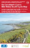 Mid-Wales
South Cycle Map - shows on-road and traffic-free paths, height
contours, 5 town centre maps, recommended linking routes connecting
the National Cycling Network with quiet roads. Includes Lôn Las
Cymru (route 8), Lôn Teifi, Elan Valley Trail, Ystwyth Trail, 6 town
centre maps, and 3 day rides. Published by Sustrans. 1:110,000
scale.
Mid-Wales
South Cycle Map - shows on-road and traffic-free paths, height
contours, 5 town centre maps, recommended linking routes connecting
the National Cycling Network with quiet roads. Includes Lôn Las
Cymru (route 8), Lôn Teifi, Elan Valley Trail, Ystwyth Trail, 6 town
centre maps, and 3 day rides. Published by Sustrans. 1:110,000
scale.
Or buy the ordinary Ordnance Survey Landranger Map from
Amazon.co.uk; scale 1:50 000 (1.25 in to 1 mile), about £9:-
Number 160 Brecon
Beacons Map covers middle & western section of park.
Number 161 The
Black Mountains Map covers eastern section.
We take no responsibility and give no guarantees or warranties,
implied or otherwise, for the content or accuracy of any linked
sites above.